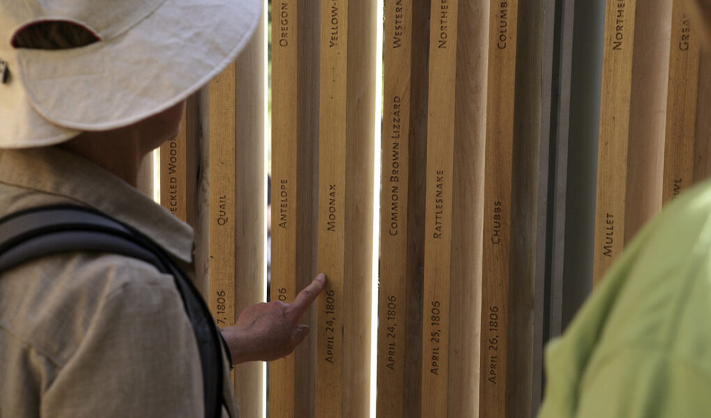
Photo: Lin, Maya. Bird Blind on the Sandy River Delta, as part of the Confluence Project. 2011.
Originally published February, 2011
Confluence Project
By Lisa Radon
You could not step twice into the same river, for other waters are ever flowing on to you. -Heraclitus
This is a project of the river that runs through it. The Columbia River that receives the Snake River, the Sandy and the Willamette on its way to the Pacific. The Columbia to which the salmon return year after year. The Columbia along whose banks numerous Native American tribes have long lived. The Columbia that Lewis & Clark followed to the sea. The Columbia that formed the last leg of the journey for many who traveled the Oregon Trail. You may not be able to step into the same river twice, as Heraclitus pointed out, but with the aid of community, of quiet monument, of art and story, you can remember the many things this confluence of rivers has been and has meant as an ecosystem, a gathering place, a resource, and a gateway. The Confluence Project, at seven sites on both the Washington and Oregon sides of the river, is a public art project that draws connections between the land, the people, and the history of the region.
The Confluence Project has been unfolding for the past nine years, and it won’t be completed until at least 2012. A team led by international artist and architect Maya Lin (she designed the Vietnam Veterans’ Memorial) with architect and landscape architect Johnpaul Jones is creating public art installations as well as works like the Jones-designed pedestrian bridge that spans State Route 14 to re-connect Fort Vancouver to the Columbia riverfront. If the flowing arc of the soil-covered land bridge is a symbol of the reconnections forged by the project, the seven story circles at Sacagawea State Park capture the scope of the community partnerships the project has fostered and cross-cultural connections it has investigated. The list of partners who came together to create this aspect of the project is long, and the stories inscribed in the low grey circles set into the site come from tribal stories, Lewis and Clark’s journals, a Yakama elder, and the natural history of the site.
At the Sandy River Delta site, the slats of an elliptical bird blind are inscribed with the names of every species noted in the Lewis and Clark journals, as well as the status of that species today. Like most sites, the Sandy River Delta site has involved restoration of habitat, an element of the project that will continue to evolve long after the last public art piece is built. Because as much as the Confluence Project is about the place, it’s about time and change and memory.
Celilo Falls only exists now as collective memory, through stories and photos. Until 1957 and the building of The Dalles Dam, Celilo Falls was one of the natural wonders of the Pacific Northwest and a traditional gathering place and important fishing location for Native Americans. Lin has said that of all the sites, “the most changed is Celilo. I imagine how much water must have been moving, the sound of the falls. Now there is a noticeable silence and the flatness of the water.” As of fall 2010, plans are in place for an extraordinary memorial, an arc that echoes the fish planks that Native American fishermen used to cantilever out over the Falls.
The Confluence Project can’t turn back the clock, can’t heal all ills, but it can honor, it can teach, and it can connect varied peoples to and through the confluence of rivers at the end of the continent at the edge of the sea.
See the Confluence Project website for maps and directions to the sites as well as stories and background about the project and its progress.
Courtesy of The Oregon Arts Commission.
Artist Credit: Maya Lin
